
Wikiexpedition/Marmaros protected massif
- Look the resolution about supporting of wikiexpedition
This Wikiexpedition was held on 22-28 of January at Marmaros reserve area, which is the part of the Carpathian Biosphere Reserve (CBR). Number of participants - 7 people (3 environmentalists and 4 photographers, who specialize on the wild nature): Василюк Олексій, BioDasha, Nataliia Shevchenko, Bogomaz Mykhayilo, Konung Yaropolk, Marushchak Oleksii.
The expedition had 6 members and 5 volunteers, who joined the expedition at their own expense. Previously it was planned that 7 members would go, but, the disease of one of them and work of another one had not allowed their plans to happen. Therefore, the expedition had some changes.
Descriptive report
[ред.]The first day
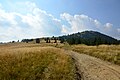
[ред.]Marmaros range is the border territory with Romania and being there must be necessarily agreed with border guards. The expedition was based in the alpine shelter, located at an altitude of 1540 m a.s.l. The first lifting day was the most difficult. Although a part of the way to the shelter from village Dilove was overcome by the GAZ-66 (we were brought to the Jalyn tract), the group managed to get to a tourist hut only in the night.
-
 Meeting of wikiexpedition participants with a researcher from CBR.
 -
 Transport from village Dilove to the beginning of our lift
 -
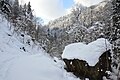
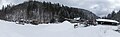
 Touristic hut near the Pip Ivan Marmaroskii


The second day
[ред.]During the preparation process wikiexpedition group planned to visit several peaks of Marmaros massif: Berlebashk, Menchul, Petros Marmarosky, Pip Ivan, trying to take photos of golden eagles, visit Yalynskii waterfall and marble quarry. However, the weather had made adjustments in most of these plans. Because of the dense sky golden eagle could not be shot at all. We were unable to get to the most of the peaks’ tops because of the ice crust, strong winds and lack of climbing equipment. So on the second day part of the group went towards Petros Marmaroskii crossing Berlebashka mountain. However, in 4 hours we had only reached the top Berlebeshka (1733.9 m a.s.l.) mountain, and its valley was covered with dense firn. The other part of our group was taking photos of surroundings near the shelter (base camp), experimenting with techniques of photo and video shooting in bad weather, in conditions of the full moon and timelapses. It was filmed Berlebashka’s top, the top of Pip Ivan Marmaroskii, a gorge near the tourist shelter.
-
 Way to Berlebashka mountain during wikiexpedition to Marmaros massif.
 -
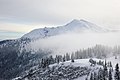
 Pip Ivan Marmaroskii mountain. Marmaros massif (Gucul Alps). CBR territory.
 -
 Pip Ivan Marmaroskii mountain. Marmaros massif (Gucul Alps). CBR territory.

.JPG)
.JPG)
The third day
[ред.]On the third day the group with two experienced guides, tried to climb the Pip Ivan, but, because of the strong wind and dense firn (snow and ice pressed together) we hadn’t overcome 200 meters to the top. There was filmed the process of raising on Pip Ivan and formation called kukhta, about which an article in Ukrainian Wikipedia was later complemented and illustrated, as by 2011 there had been only a list of people with the surname “Kukhta” without explanation the content of this word.
-
 Pip Ivan Marmaroskii, on the way to the ridge
 -
 Winter slopes of Pip Ivan Marmaroskii
 -
 An attempt of the expedition to climb to the snow top of Спроба підйому єкспедиції на засніжену вершину Pip Ivan Marmaroskii in difficult weather conditions


The fourth day
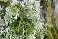
[ред.]On the fourth day the weather became better. This made it possible to take photos of rare lichens, White Stream, and climb to the Yalynskii waterfall. Before going to the village Dilove for the next day the group spent one night at the turn to the waterfall. To get here from the shelter on the foot of Pip Ivan we had to come down to about 900 meters and after that regain 700 meters. We should also mention waterfall - the highest fountain in the Carpathians. Unlike well-known Shipot and Hooke, Yalynskii waterfall is relatively inaccessible, that allows him to keep its original appearance. In this case, shooting videos and photos of this unique tract is the most interesting thing especially in winter, when a thin stream turns into massive accumulation of ice-buds. Also, in the valley of river Bilyy there were found specimens of endangered lichen Lobaria pulmonaria, listed in the Red Book of Ukraine.
-
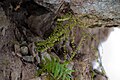
 Members of the expedition are examining a lichen Lobaria pulmonaria, that was found on the tree trunk
 -

-
 Orchid Neottia nidus-avis
 -
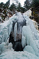 Yalynskii waterfall, the highest in the Carpathians
 -
 Yalynskii waterfall, the highest in the Carpathians
 -
 Yalynskii waterfall, the highest in the Carpathians


Expedition participants consider it to be necessary to significantly develop wikiinformation about national parks, biospheral and natural reserves. To reach this goal, we offer:
To develop content structure of each of the following articles modeled on article Dunai Biosphere Reserve, which is currently the most complete and extensive. To connect pages contently confined to each specific reserve or national park (towns, mountains, hotels and camp sites, touristic routes, place names, endemic species of flora and fauna, etc.) among themselves and with the article about protected areas. To ask the Nature Reserve Fund to provide information about their institution (for example - the first volume chronicle of national park or nature reserve that contains all the basic information) for placing it on the wiki *. To translate articles about reserves and national parks of Ukraine in other languages. To conduct wikiexpeditions, theme weeks and other incentives aimed at filling Ukrainian Wikipedia with thematic information about protected areas.
Members of the expedition received a letter from the Ministry of Environment and Natural Resources, from which it follows that all the information on the Nature Reserve Fund is open.
Materials got and improved as a result of wikiexpedition
[ред.]Articles, created on Wikipedia
[ред.]- Живокіст серцевидний (Symphytum cordatum)
- Дрік малонасінний(Genista oligosperma)
- Жовтець карпатський (Ranunculus carpaticus)
- Дзвоники карпатські (Campanula carpatica)
- Червона книга Українських Карпат(Red book of Ukrainian Carpathians)
- Лобарія легеневоподібна (Lobaria pulmonaria)
- Філка відхилена (Viola declinata)
Improved articles in Wikipedia
[ред.]- Карпатський біосферний заповідник (Carpathian biosperal reserve)
- Мармароський заповідний масив (Marmaros protected massif)
- Кузійський заповідний масив (Kuziyskii protected massif)
- Чорногірський заповідний масив (Chornogoriyskii protected massif)
- Угольсько-Широколужанський заповідний масив (Ugolsko-Shirokoluzhanskii protected massif)
- Свидовецький заповідний масив (Svidovetskii protected massif)
- Мармароський масив (Marmaros massif)
- Ялинський водоспад (Yalynskii waterfall)
- Кухта (Kukhta)
- Мармарощина (Marmaros region)
- Гуцульські Альпи (Gucul Alps)
- Рахівські гори (Rakhiv mountains)
- Жербан (Zherban)
- Берлебашка (Berlebashka)
- Піп Іван Мармароський (Pip Ivan Marmaroskii)
- Петрос (Мармароси) (Petros (Marmaros area))
- Гніздівка звичайна (Neottia nidus-avis)
- Вікіпедія:Вікіекспедиція
Written Wikinews
[ред.]Created article on Wikijourneys
[ред.]- uk:Marmaros protected massif on Wikijourneys
Ilustrated articles on Wikipedia
[ред.]- Гуцульські Альпи (Gucul Alps)
- Піп Іван Мармароський (Pip Ivan Marmaroskii)
- Ялинський водоспад (Yalynskii waterfall)
- Петрос (Мармароси) (Petros (Marmaros region))
- Берлебашка (Berlebashka)
- Живокіст серцевидний (Symphytum cordatum)
- Лобарія легеневоподібна (Lobaria pulmonaria)
- Жовтець карпатський (Ranunculus carpaticus)
- Гніздівка звичайна (Neottia nidus-avis)
- Папороть чоловіча (Dryopteris filix-mas)
- Аспленій волосоподібний (Asplenium trichomanes)
- Багатоніжка звичайна (Polypodium vulgare)
- Мармароський заповідний масив (Marmaros protected massif)
- Трутовикові (Polyporaceae)
- Саламандра вогняна(Salamandra salamandra)
- Кухта (Kukhta)
- Лавина (Avalanche)
- Ропуха звичайна (Bufo bufo)
- Тритон карпатський (Lissotriton montandoni)
- Bielzia coerulans
- Філка відхилена (Viola declinata)
Articles, to which videos were added
[ред.]- Кухта (Kukhta)
- Піп Іван Мармароський (Pip Ivan Marmaroskii)
- Берлебашка (Berlebashka)
- Ялинський водоспад (Yalynskii waterfall)
Wikiexpedition article in ukrainian language
[ред.]Вікіекспедиція/Мармароський заповідний масив
Photogallery
[ред.]Photos, taken during the Wikiexpedition and uploaded to Wikimedia Commons
[ред.]-
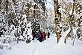
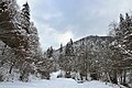 The forest along river Bilyy, Gucul Alps, Rakhiv district
 -
 Forested rocky banks of the river Bilyy, Gucul Alps, Rakhiv district. The territory of CBR.
 -
 River Bilyy, Gucul Alps, Rakhiv district. The territory of CBR.
 -
 River Bilyy, Gucul Alps, Rakhiv district. The territory of CBR. A part of touristic route “v. Dilove – r. Bilyy – m. Pip Ivan”.
 -
 River Bilyy, Gucul Alps, Rakhiv district. The territory of CBR. Going along touristic route “v. Dilove – r. Bilyy – m. Pip Ivan”.
 -
 Forests along banks of river Bilyy, Gucul Alps, Rakhiv district. The territory of CBR.
 -
 The territory of CBR. River Bilyy, Gucul Alps, Rakhiv district.
 -
Meeting of wikiexpedition participants with a researcher from CBR.
-
 Polyporal mushrooms on the trunk of dead tree.
 -
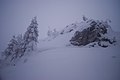
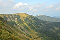
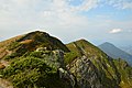
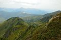
 Landscape that could be seen from the saddle between Pip Ivan Marmaroskii and m. Berlebashka. Right away Romanian top Ferkeu is visible.
 -
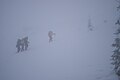
Transition to m. Berlebashka during the wikiexpedition to Marmaros massif.
-
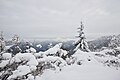
 The territory of CBR. Gucul Alps.
 -
 m. Zherban and m. Polonynka are visible.
 -
 Fresh snow balls that roll down the mountain slope and are one of the signs of avalanches.
 -
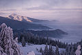
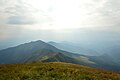
 m. Pip Ivan Marmaroskii. Marmaros massif (Gucul Alps). The territory of CBR.
 -
m. Pip Ivan Marmaroskii. Marmaros massif (Gucul Alps). The territory of CBR.
-
m. Pip Ivan Marmaroskii. Marmaros massif (Gucul Alps). The territory of CBR.
-
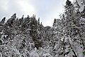
 On this photo you can see how forest communities turn into woodlands and shrub with increasing height.
 -
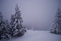
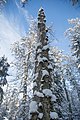
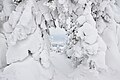 Kukhta – snow massifs sticking on the branches of trees in conditions of high humidity and low temperature. Marmaros massif of Ukrainian Carpathians.
 -
 In the background it is seen the Romanian Maramoros array – m. Ferkeu.
 -
 At considerable heights small trees and shrubs in winter fully are covered with a layer of extruded snow – kukhta. The territory of CBR.
 -
 At considerable heights small trees and shrubs in winter fully are covered with a layer of extruded snow – kukhta. The territory of CBR.
 -
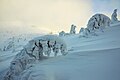 At considerable heights small trees and shrubs in winter fully are covered with a layer of extruded snow – kukhta. The territory of CBR.
 -
 At considerable heights small trees and shrubs in winter fully are covered with a layer of extruded snow – kukhta. The territory of CBR. The way to m. Pip Ivan Marmaroskii.
 -
Members of the expedition are looking at lichen Lobaria pulmonaria, that was found on a tree trunk.
-
Members of the expedition are looking at lichen Lobaria pulmonaria, that was found on a tree trunk.
-
Neottia nidus-avis, Гніздівка звичайна, the family of Orchids
-
Yalynskii waterfall, the highest in Carpathians.
-
Yalynskii waterfall, the highest in Carpathians.
-
Yalynskii waterfall, the highest in Carpathians.
-
Pip Ivan Marmaroskii, on the way to the ridge.
-
A try of the expedition to climb on the snowy top of Pip Ivan Marmaroskii in difficult weather conditions.
-
Winter slopes of Pip Ivan Marmaroskii
-
 A view from the foot of Pip Ivan Marmaroskii to the valley of stream Big Rososh.
 -
 A view from the foot of Pip Ivan Marmaroskii to the valley of stream Big Rososh.
 -
 A nightview from the foot of Pip Ivan Marmaroskii ridge on Berlebashka mountain.
 -
Transport from village Dilove to the beginning of our lift.
-
Touristic hut in the anticline near Pip Ivan Marmaroskii.
-
 Dryopteris filix-mas. Mamaros massif of Carpathian biospheral reserve.
 -
 Asplenium trichomanes. Marmaros massif of Carpathian biospheral reserve.
 -
 Polypodium vulgare near the foot of Yalynskii waterfall. Marmaros massif of Carpathian biospheral reserve.
 -
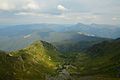
 Petros Marmaroskii mountain. A view from the anticline between Pip Ivan Marmaroskii and Berlebashka.
 -
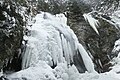 Yalynskii waterfall in winter.
 -
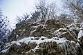 Rocks, situated along the White stream.
 -
 White stream
 -
 Beech-fir forest.
 -
 Lobaria pulmonaria.
 -
 Polyporuses.


.JPG)


Panoramas, uploaded to the Wikimedia Commons
[ред.]-
 Marmaros quarry, outskirts of village Dilove, Rakhiv district, Panorama 1
 -
 Marmaros quarry, outskirts of village Dilove, Rakhiv district, Panorama 2
 -
 Marmaros quarry, outskirts of village Dilove, Rakhiv district, Panorama 3
 -
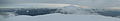
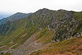
 A view from the top of m. Berlebashka to the side of v. Dilove.
 -
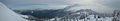 A panorama of Pip Ivan Marmaroskii mountain from the foot of m. Berlebashka.
 -
 A view from the top of m. Berlebashka to the side of m. Pip Ivan Marmaroskii.
Temporarily uncertain plants
[ред.]-
 Temporarily uncertain fern.
 -
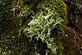 Temporarily uncertain lichen.
 -
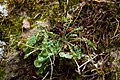 Temporarily uncertain plant


Photos by expedition topic, uploaded to Wikimedia Commons from the participants’ archives
[ред.]-
 Symphytum cordatum on the territory of Ugolsko-Shyrokoluzhanskii massif of CBR.
 -
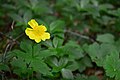 Ranunculus carpatica on the territory of Ugolsko-Shyrokoluzhanskii massif of CBR.
 -
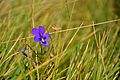 Viola declinata – alpine species, photo taken on Marmaros ridge.
 -
 Temporarily uncertain lichen. Ugolsko-Shyrokoluzhanskii massif of CBR.
 -
 Salamandra salamandra basking in the spring sun.
 -
 A view on the mountain Stig, Marmaros ridge.
 -
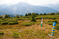
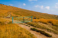
 Old gate on the border road, Marmaros ridge.
 -
 Border columns Ukraine-Romania.
 -
 Marmaros ridge, trails of glacier movements - kars.
 -
 Barbed wire at the Ukrainian-Romanian border, Marmaros ridge.
 -
 Ground road on the Marmaros ridge, Ukraine-Romanian border.
 -
 A view on Pip Ivan Marmaroskii from Marmaros ridge.
 -
 A small lake on Marmaros ridge (near m. Pip Ivan Marmaroskii).
 -
 Marmaros ridge, marble rocks’ outputs.
 -
 Marmaros ridge. Gucul Alps. View from m. Pip Ivan.
 -
 The top of the mountain Pip Ivan Marmaroskii, Gucul Alps.
 -
 Ice circus, m. Pip Ivan Marmaroskii.
 -
 The view from the top of the m. Pip Iva Marmaroskii to the Romanian part of Marmaros.
 -
 Nothern spurs of m. Pip Ivan.
 -
 Ice kar on the northern slope of the m. Pip Ivan Marmaroskii.
 -
 Berlebashka mountain, view from the slope of m. Pip Ivan Marmaroskii.
 -
 Pip Ivan Marmaroskii, a view from the anticline.
 -
 The ridge and the top of Pip Ivan Marmaroskii.
 -
 Ferkeu mountain, a view from the border road of soviet times.
 -
 Neniaska mountain and remnants of the Iron Curtain that pass through it.
 -
 Ferkeu mountain and columns that indicate state border.
 -
 border road of soviet times, that goes along a touristic route on Marmaros ridge.
.JPG)


Schematic representation of tourist routes (based on OSM)
[ред.]-
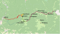 Schematic representation of hiking trails from the village Dilove to the Maramorosh mountain ranges: 2 variants to lift to the meadow Lysycha: Route №1 (red line, coincides with the route marked by Foundation "Carpathian paths" red marker) and route №2 (blue dotted line, not marked, is laid on the soviet border road); rise on Berlebashka (1734 m) and Petros Marmaroskii (1781 m) - the yellow line; traverse of Pip Ivan Marmaroskii (1936 m) - the green line; passing of Marmaros ridge (along the border divider) - purple line.
 -
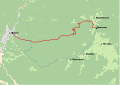 Schematic representation of hiking trails from the village Dilove to the Lysycha mountain valleys : Route №1 (coincides with the route marked by Foundation "Carpathian paths" in red marker.) And Route №2 (not marked, it is laid on the soviet border road)
 -
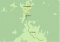 Schematic representation of hiking trails from the meadow Lysycha: "The rise on Berlebashka (1734 m) and Petros Marmaroskii (1781 m)" and "Traverse of Pip Ivan Marmaroskii (1936 m)"
 -
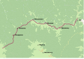 Schematic representation of the tourist route of passing the Marmaros ridge (along the border divider from soviet times).


Videos, uploaded to the Wikimedia Commons
[ред.]-
There is a non-freesing winter headspring in 400 meters from the touristic hut.
-
During the coming down to Rakhiv, in the penultimate day of the expedition, the group got lucky with a sunny weather.
-
Snow buildups on trees and other objects turn ordinary things into fabulous ones.
-
On the second day of the expedition to Marmaros, the group tried to get to Petros marmaroskii. However we only managed to get to m. Berlebashka.
-
Stream White
-
In winter the waterfall covers in ice, that is beautiful and dangerous at the same time (during the thaw it falls and can hurt those who stay close).
-
During the winter expedition to Marmaros ridge there was a try to climb to Pip Ivan Marmaroskii. But ice and fog didn’t allow to do that.
-
In the penultimate day of the expedition, the group got lucky with a sunny weather.
-
During the winter expedition to Marmaros ridge there was a try to climb to Pip Ivan Marmaroskii. But it failed because of bad weather conditions.
-
Yalynskii waterfall – the highest in Ukrainian Carpathians. It is hidden in Yalyn tract.